
The Wave Hike Guide (2026): Route, Safety, What to Pack, and When to Go
Hiking The Wave in Coyote Buttes North is an unforgettable experience — a journey through swirling sandstone, glowing light, and complete desert silence. But this hike is not a simple stroll. The trail is unmarked, the sun can be brutal, and navigation takes focus. In this 2026 guide, we share everything you need to know to prepare for The Wave hike: where the trail starts, how to navigate safely, what to pack, and when to go for the best light and weather. After finally winning our permit and hiking The Wave ourselves, Chris and I share firsthand tips that will help you plan your day and stay safe on the trail.
This article may contain affiliate / compensated links. For full information, please see our disclaimer here.
Hiking The Wave – Our Experience
After years of trying, Chris and I finally won our permit and hiked The Wave in Coyote Buttes North — and it was one of the most surreal days we’ve ever spent in the desert. We started early, long before sunrise, driving the bumpy House Rock Valley Road in our 4×4. The morning light painted the cliffs gold, and we knew the day would be special.
The hike itself wasn’t long, but it demanded constant attention. There’s no marked trail, and navigation across slickrock and sandy washes can be tricky. We stopped often to take photos, check our GPS, and soak in the silence — it felt like walking on another planet.
By the time we reached The Wave, the sun had climbed high enough to light up every curve and color. It was worth every failed lottery attempt. That day taught us how important it is to come prepared, know the route, and respect the fragile landscape. In the sections below, we’ll share exactly how to plan your own hike and what to expect once you hit the trail.
Agnes’ Advice: You must have a permit for this hike, so make sure to read our Wave Lottery and Permit Guide before you go — it explains exactly how to apply and increase your chances of winning.
Where The Wave Is and How to Get There
The Wave sits within the Coyote Buttes North area of the Paria Canyon–Vermilion Cliffs Wilderness, on the Arizona–Utah border. It’s managed by the Bureau of Land Management (BLM) and lies about halfway between the towns of Kanab, Utah, and Page, Arizona. If you’re building your itinerary, our Arizona road trip guide can help you connect all the highlights into one route.
Getting To The Trailhead
The hike starts at the Wire Pass Trailhead, located off House Rock Valley Road — a dirt road that connects U.S. Highway 89 with U.S. Highway 89A. The turnoff is about 40 miles east of Kanab or 35 miles west of Page.
Driving Directions
- From Kanab: drive east on U.S. 89 for about 40 miles and turn right (south) onto House Rock Valley Road between mile markers 25 and 26.
- From Page: drive west on U.S. 89 for about 35 miles and turn left (south) onto House Rock Valley Road.
Then drive about 8.3 miles down the dirt road to reach the Wire Pass parking lot.
Road Conditions
House Rock Valley Road is unpaved and can be rough. In dry conditions, most high-clearance vehicles can handle it. But after rain, the clay surface turns slick and nearly impassable — even for 4WD. Always check weather and road reports before heading out, and never risk it if storms are in the forecast.
There are no services or cell coverage along the road. Bring plenty of water, a full tank of gas, and know your route in advance.

The Wave Hike Overview
The hike to The Wave is about 6.4 miles round trip from the Wire Pass Trailhead. It’s not especially long, but it’s considered strenuous because there’s no marked trail, little shade, and plenty of soft sand and slickrock to cross.
Quick Facts
- Distance: 6.4 miles round trip
- Elevation gain: about 420 feet
- Trailhead elevation: 4,807 feet
- The Wave elevation: 5,225 feet
- Hiking time: 3–4 hours of walking, or up to 6–8 hours with photo stops
- Difficulty: Strenuous due to terrain, sun exposure, and navigation challenges
What Makes It Difficult
The biggest challenge isn’t the distance — it’s route finding. The landscape is open and full of similar-looking sandstone ridges, so it’s easy to get disoriented. There are no signs, cairns, or GPS signals to guide you. You must be confident using a map, compass, or GPS device.
Temperatures can also vary dramatically. In summer, it’s common to exceed 100°F (38°C) by midday, while winter mornings can dip below freezing. Bring more water than you think you’ll need and prepare for both heat and wind.
BLM rangers provide a detailed map and safety briefing when you pick up your permit — review it carefully and keep it accessible throughout your hike.
Rules You Must Follow
- Permit required: Only visitors with a valid Coyote Buttes North permit may enter the area.
- Day use only: Camping overnight is not allowed anywhere on the trail.
- No drones: Drones and other aerial devices are prohibited within the Paria Canyon–Vermilion Cliffs Wilderness.
- Stay on durable surfaces: Walk on rock or sand; avoid stepping on biological soil crusts.
- Pack it in, pack it out: There are no trash bins or toilets — carry out everything you bring.
- Stay together: All group members listed on the permit must hike together.
BLM rangers will review these rules during the required safety briefing. Respecting them helps protect this fragile landscape and ensures access for future visitors.

Trail Description: Wire Pass to The Wave
The adventure to The Wave begins at the Wire Pass Trailhead. You’ll sign the trail register near the parking lot and follow the path down into a dry wash that runs east.
From the Trailhead to the First Junction
Walk in the sandy wash for about 0.5 miles. You’ll see red cliffs rising on both sides. When the wash splits, the trail to The Wave leaves the wash to the right and begins climbing gently onto open slickrock. This is where most hikers start using their GPS or map to stay on track.
Across the Open Desert
Once you climb above the wash, the trail becomes cross-country. You’ll traverse long stretches of sandstone and sand dunes, using distinctive landmarks like the dome-shaped buttes and a large sandstone ridge ahead. The terrain is uneven, so take your time and check your route often.
Final Approach to The Wave
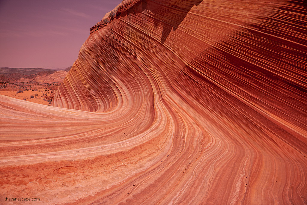
The last part of the hike winds between sculpted sandstone formations before descending into the famous wave-like basin. As you approach, you’ll recognize the signature curves and stripes that make this formation so iconic.
There are no signs marking the end of the trail — just a natural amphitheater of swirling red, orange, and yellow stone. Take your time exploring, but be careful where you step. The rock is fragile and easily damaged.
Getting Back
Many hikers find the return trip more confusing than the way in. Always mark key waypoints on your GPS or take photos of the landmarks behind you as you go. This will make it easier to retrace your route to Wire Pass Trailhead later in the day.

When to Hike The Wave
You can hike The Wave year-round, but the experience changes dramatically with the seasons. Weather, light, and road conditions all play a big role in how your day unfolds.
Spring (March–May)
Spring is one of the best seasons to hike The Wave. Daytime temperatures are mild, wildflowers bloom, and the sandstone colors glow under the soft spring light. It’s also one of the busiest times, so permits are harder to get.
Summer (June–August)
Summer brings intense desert heat, often above 100°F (38°C). There’s little shade along the route, and heat exhaustion is a serious risk. If you visit in summer, start hiking at sunrise, carry plenty of water and electrolytes, and plan to finish by late morning.
Afternoon monsoon storms are common in July and August, making House Rock Valley Road impassable after heavy rain.
Fall (September–November)
Fall offers the same great conditions as spring — clear skies, comfortable temperatures, and beautiful light for photography. September and October are especially good months to plan your hike.
Winter (December–February)
Winter has the highest odds of winning a permit but brings colder weather and shorter days. Expect freezing mornings and possible snow or ice on slickrock. However, the soft light and empty trails can make it an unforgettable time to visit.
Best Time of Day
Start early. Sunrise or shortly after gives you cooler temperatures, golden morning light, and plenty of time to navigate safely. The best light for photography inside The Wave usually falls between 10 a.m. and 2 p.m., when the sun fills the curved walls with color.

Safety Tips for Hiking The Wave
The Wave is stunning — but it’s also remote, exposed, and easy to underestimate. Every year, hikers get lost or suffer heat-related illnesses here. Preparation is key.
1. Start Early
Begin your hike at sunrise. You’ll avoid the harshest heat, enjoy calmer winds, and have more time for photography without rushing.
2. Bring Plenty of Water
Carry at least one gallon (3.8 liters) per person in summer, and slightly less in cooler months. There’s no water on the trail. Drink regularly and balance hydration with salty snacks to prevent hyponatremia (low sodium levels).
3. Protect Yourself from the Sun
There’s almost no shade on this route. Wear a wide-brim hat, UV-protective clothing, sunglasses, and sunscreen. Long sleeves keep you cooler than bare skin under strong desert sun.
4. Know the Signs of Heat Illness
Headache, dizziness, nausea, muscle cramps, or confusion can signal heat exhaustion or heat stroke. Stop, rest in shade if possible, cool down, and hydrate.
5. Watch the Weather
Avoid hiking if heavy rain is forecast. House Rock Valley Road can become impassable after just one storm. Flash floods can also occur in washes. Always check weather updates before driving or starting your hike.
6. Use a Map and GPS
Navigation is the hardest part of this hike. Bring a map, compass, GPS, or offline navigation app and mark your route carefully. BLM rangers give a detailed map with your permit — study it before heading out.
7. Dress in Layers
Morning temperatures can be near freezing in winter, then rise quickly during the day. Pack a warm jacket or fleece for early hours and light layers for later.
8. Leave No Trace
There are no toilets or trash bins. Pack out all waste, stay on rock or sand, and avoid stepping on fragile soil crusts. Drones are prohibited in the entire wilderness area.
9. Know When to Turn Around
If you lose your route, run low on water, or feel unwell, turn back early. Getting lost in this desert is dangerous — even for experienced hikers.

What to Pack for The Wave Hike
You’ll be hiking through desert wilderness with no services, no shade, and no cell coverage — so packing smart is essential. Here’s what Chris and I recommend based on our own experience hiking The Wave.
Essentials
- Permit and ID: You must carry your Coyote Buttes North permit and a valid photo ID. Rangers regularly check hikers.
- Navigation tools: Printed map, compass, and GPS device or offline app (such as Gaia GPS or AllTrails+). Mark waypoints on the way in.
- Plenty of water: At least 1 gallon (3.8 liters) per person in warm weather, plus electrolytes or sports drink.
- Snacks and lunch: High-energy foods like nuts, jerky, protein bars, or sandwiches. Avoid heavy meals that can cause fatigue in the heat.
- Sun protection: Wide-brim hat, UV shirt, long sleeves, sunglasses, sunscreen, and lip balm with SPF.
Clothing
- Layered outfit: Lightweight base layers for breathability, fleece or light jacket for early mornings, and a wind shell for breezy ridges.
- Footwear: Sturdy hiking shoes or boots with good traction for slickrock and sand. Gaiters help keep sand out.
- Socks: Moisture-wicking socks — bring an extra pair if your feet tend to blister.
Safety and Comfort
- First-aid kit: Include bandages, blister care, electrolytes, and pain relievers.
- Emergency gear: Headlamp or small flashlight, whistle, lightweight emergency blanket, and a small multi-tool.
- Camera gear: Protect lenses from sand; bring a microfiber cloth or blower.
- Small trash bag: Pack out all waste — including tissues and food wrappers.
Optional but Useful
- Trekking poles: Helpful for sandy or uneven terrain.
- Portable shade umbrella: A lifesaver on hot summer days.
- Cooling towel: Keeps your body temperature down when the sun is intense.
Pack light but never skip essentials. Every year, hikers underestimate how demanding this short trail can be — preparation makes the difference between a safe adventure and a rescue call.

Photography Tips and Best Light at The Wave
The Wave is one of the most photographed places in the American Southwest — and for good reason. Its smooth sandstone curves, vivid colors, and natural light create surreal compositions all day long. Here’s what we’ve learned from our own visit.
Best Time of Day
The ideal light hits The Wave between 10 a.m. and 2 p.m. That’s when the sun is high enough to illuminate the entire basin and make the red, orange, and yellow layers glow. Early in the morning, parts of the formation remain in shadow.
If photography is your main goal, plan to reach The Wave by midmorning. Leave the trailhead around sunrise to give yourself plenty of time for navigation and photo stops along the way.
Midday Reflections
While midday light can be harsh elsewhere, here it brings out the wave-like striations and reveals subtle color variations in the rock. Cloudy days also create soft, diffused light — perfect for close-ups and detailed textures.
Lens and Composition Tips
- Bring a wide-angle lens to capture the full sweep of the formation.
- A polarizing filter helps reduce glare and deepen the colors.
- Keep an eye on footprints — they can spoil an otherwise perfect shot. Wait for the wind to clear sand if needed.
- Move slowly and look for small details — every curve and ripple tells a different story.
Protecting Your Gear
Sand and wind are constant here. Keep cameras and lenses in protective pouches, use a microfiber cloth to wipe dust, and avoid changing lenses in windy conditions.
Stay Aware
It’s easy to get lost in photography and forget the time. Check your return route, monitor your water supply, and start heading back early enough to reach the trailhead before dark.

Leave No Trace and Responsible Hiking
The Wave sits in one of the most delicate landscapes in the American Southwest. Every footprint and every step matters. Preserving it is the reason for the strict permit system — and it’s up to all of us to protect it for the next visitors.
Simple Rules to Follow
- Stay on rock or sand. Avoid stepping on black biological soil crusts — they can take decades to recover.
- Pack out everything. There are no trash bins or toilets. Bring a small bag for tissues, food wrappers, and all waste.
- No drones. They’re prohibited throughout the Paria Canyon–Vermilion Cliffs Wilderness.
- Leave rocks and fossils where you find them. Even small changes damage this fragile area.
- Respect other hikers. Keep noise low and share the space — everyone here waited for a chance to see The Wave.
Following these simple practices ensures that this landscape stays pristine — just as breathtaking for the next lucky hiker as it was for you.
Final Thoughts
Hiking The Wave in Coyote Buttes North is an experience you’ll never forget. It’s more than a photo spot — it’s a place that humbles you with silence, color, and scale. Every curve in the sandstone tells the story of millions of years of wind and water shaping the desert.
It takes effort to reach and even more patience to win the permit, but once you stand inside The Wave, you’ll understand why it’s worth every try. Prepare well, respect the rules, and take your time to truly experience the landscape.
If you haven’t applied yet, read our Wave Lottery and Permit Guide to learn how to get your permit. And if you already have one — congratulations! You’re about to explore one of the most remarkable places in the Southwest.
Do You Like It? Pin It For Later!

